Showing posts with label Prudhoe Bay. Show all posts

Friday, June 24, 2011

Alaska Trip 2011: June 13 - Arctic Adventure Last Day

This is page 25 of our Alaska 2011 trip journal. Click here for the first page. If you want to bookmark this journal, http://jeanne-travels.blogspot.com always links to the newest page.

Today we start the long journey back to Fairbanks. We are going to try to make the entire 500 miles today. Maybe we'll get there before dark. Ummm.... I think that would be about August. It's been at least 2 or 3 weeks since we have seen darkness at night. Fairbanks is south of the Arctic Circle, so the sun does go down, but it doesn't get very dark. There's just a little twilight for the hour or two that the sun dips below the horizon.

Strange Gas Station
Of course we have to fuel up before hitting the road. We located the gas station on the map, and then drove right by it, because it didn't look like a gas station. The pumps are inside a small metal shack, with tanks behind to hold the fuel. I'm guessing the above-ground tanks are to protect them from frost heave, and the little shack is to keep the pumps from freezing or getting covered by snow. You can watch the meter through the window.


On the Road Again
It's about 32° and overcast as we head south, and the clouds ahead look like snow. The area gets only about 4 inches of rain a year, most of it in the form of snow. Compare that to the Sahara Desert, which averages over 7 inches in a year. Yet the area is basically a flat wetland, with standing water everywhere. The permafrost is very close to the surface here, so when the snow melts there is basically no place for it to go.

I have two pictures of the tundra to share. One shows the frost heaves in the ground, and the other just the expanse of wetland.


Caribou Crossing
We had to wait for a herd of caribou to cross the road, and then saw more grazing just down the road.


Road Conditions
Here are two more pictures illustrating the road conditions. The first is on one of the rare sections of paved road. notice the crack across the road? Follow it down the side to see how deep it is. The other picture is after we ran into the snow. It shows what happens to the unpaved sections of road when they get wet. Needless to say, we are now collecting even deeper layers of mud.
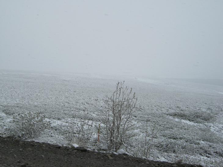

Snowing Harder

At this point, it has started to snow harder. The mountains are still in the distance, but you can already tell there is more snow on them than there was when we came by here yesterday. The temperature is dropping, down to 30° so far, and the snow is starting to stick a little more.


Ghost Mountains

This was such a strange effect to me. The snow and fog made the mountains look shadowy, like an eerie ghost.


Atigun Pass Revisited

Atigun Pass looks a lot different than it did yesterday. It was a bit colder, too - the temperature dropped to 28° as we came across. There was no ice or snow on the road when we were here, just the mud. Later on, we did hear one trucker talk about having to chain up to cross the pass in the morning.


South of the Pass
Once we got through the pass, the weather changed just as abruptly as it did going the other way. The temperature started rising, and the snow changed to rain, and eventually cleared up. After that, it stayed dry most of the way back, until we ran into a light shower near Fairbanks


More Mud
When the snow changed to light rain, it was still making lots of fresh mud, but the rain loosened it a little at the top, causing it to run rivers of mud down the side. Yuck. And the picture does not even show how deep it is on the running boards and back bumper.

More Wildlife

We got a pretty good look at this moose. You can even see the velvet on his freshly sprouted antlers. You might have to zoom in the picture to get a better look.


We saw two different foxes, within about half an hour of each other. Believe it or not, these are red foxes. This surprised me, since they are not the normal red color, but when I looked them up to see what they were, I learned that red foxes come in about four color variations. This one is called a cross fox, because the shading on the back and shoulder resembles a cross. You can see it best in the second picture. The second fox, in the lower two pictures, was carrying some kind of prey. We did not get a good look at what it was.


Alpenglow and Rainbows
As we got back near Fairbanks, we were treated to two different visual effects - alpenglow and a rainbow. Alpenglow is what is making the green trees glow red. Has something to do with the sun being below the top of the hill, and the rays refracting or bending over the top. The sun has not really gone down yet, but depending on which direction we are pointing on this winding road, it may or may not be behind a mountain.


By the way, these pictures were taken a little after midnight, by the light of the midnight sun. We did make it back to Fairbanks before sunset, which was around 12:30.

Back in Fairbanks
Our Arctic adventure was an amazing journey - I'm really glad we decided to go ahead with it. There are so many things in this world that you think you understand, but until you experience it, you really don't understand. We could have spent more money and flown to Deadhorse, but it would not have been the same experience.


Wednesday, June 22, 2011

Alaska Trip 2011: June 12 - Arctic Adventure Day 2

This is page 24 of our Alaska 2011 trip journal. Click here for the first page. If you want to bookmark this journal, http://jeanne-travels.blogspot.com always links to the newest page.

(If you do not see the map, click on "View Larger Map" below)

View Larger Map

A = Fairbanks; B = Coldfoot; C = Deadhorse (Prudhoe Bay)

Today we left Wiseman and drove all the way to Deadhorse. Except for the first few miles, troad conditions were mostly worse on this stretch of road. We ended up having to hurry a little so we could make the 5:00 p.m. Arctic Ocean tour.

Wiseman, AK
Wiseman
67° 25' North
Sunrise May 30
Sunset July 14
It's so pretty and green here, it's hard to believe we are 75 miles north of the Arctic Circle. When spring arrives, things grow pretty fast, because the season is short. All the sunlight probably helps get things going quickly, too.

Wiseman is a pretty little town. Unlike Coldfoot, I think people actually live here. I know the couple who rented us the cabin stay here with their kids, and I think there are a handful of other families as well.


Interesting effect, with the sun behind the hill.

The Wiseman post office. Ok, it's not the post office any more, but it was until 1958. Now they probably get their mail at the shack in Coldfoot.
The first few miles, we had beautiful, freshly paved road. Unfortunately that did not last long.


The Arctic Tree Line
We are starting to rise in elevation again, and this time we will reach the arctic tree line. We are headed for the Brooks Range, the last mountains we will cross on our way north. We stopped at a rest area with placards pointing out the farthest north spruce tree. Unfortunately it is now dead, but here is what we learned from the placards. Altitude and latitude both contribute to making an environment inhospitable for trees, so the timberline will vary, depending on how close you are to the equator. It's around 19,000 feet in Ecuador, 12,000 in Colorado, 7,500 in Alberta, and only 2,500 feet here.

These pictures show the view just above the tree line. One shows the willow bushes, which also disappear shortly up the hill. In the other, you can see where the highway goes up toward Atigun Pass.


Atigun Pass
At 4739 feet, Atigun pass is the highest spot on the Dalton Highway. At this combination of latitude and elevation, almost nothing grows, giving the mountains an almost desolate look. The Brooks Range is almost like a wall holding the coldest temperatures to the north. We saw the temperature go from 56 to 36 as we crossed the pass, and a little farther up the road, we ran into snow.


We continue to experience waves of flurries and light snow, but nothing is sticking to the ground. We have had to slow down considerably, not because of the snow, but because the unpaved road has become less hard surfaced, and more loose gravel. I think that is because the underlying ground has more rock and less soil. (Geologists get annoyed if you call it dirt, but it's all the same to me.) There are still occasional sections of pavement, but they are fewer and father between.

Along this stretch of road, we are seeing numerous arctic caribou. Most of these pictures were taken out the side window, so if you see specks and smears, it is snow, not dirty windshield.


We also saw one musk ox. You can't see it very well because of the distance. The gull was just posing on a pile of rock near where we saw the musk ox. Other than the animals, the scenery is not much to look at here. Fascinating if you have never seen it before, but nothing you want to frame and hang on your wall.


Deadhorse / Prudhoe Bay
Like Coldfoot, Deadhorse is not exactly what I expected. Thousands of people work here in the oil fields but I doubt many people actually live here. The oil workers all live somewhere else. They fly up for two to three week work shifts and then fly back for a week or so. The "hotels" are really just work camps that they have opened up to tourists as well. There are no restaurants - you take your meals in the dining room with the oil workers and any other tourists, and your room rate includes the cost of three meals and any snacks you want while you are there.

We chose the hotel that had the most positive reviews, or should I say the fewest negative reviews. Here is a picture of the one where we stayed, and the one there the oil field tour began. We went for the luxury room - with a private bath. With the regular rooms, you go down the hall to go to the bathroom or to take your shower. The room was clean, but tiny. The bed was jammed against the wall on one side, and there was barely room for a chair on the other.


The Prudhoe Bay General Store is more or less the same construction as the hotels, just no windows. That's where we found the "end of the Dalton Highway" sign for the photo op. And just in case anyone doubts we are near the top of the world, take a look at the "downward facing dish". They are this way in fairbanks, too. The first time I saw one, I thought the bracket must be broken or something, but they are all that way.


Between the wetness from the snow, and a few more patches of road work, we managed to add a few more layers of mud onto the trailblazer. Can you see what looks like a hitching post along the row of parking places? These have electrical cords hanging from them, and vehicles that live here have plugs dangling from the grill or bumper. They have engine block heaters, oil pan heaters, and/or warming blankets so their cars will stilll start when it gets to 40 or 60 below. I even saw a few of them plugged in, even though it was not supposed to go below about 29 while we were there. Force of habit, I guess.

Oil Field / Arctic Ocean Tour
All the property that borders the Arctic Ocean is behind the oil company security lines, so the only way to get there is to schedule an oilfield tour. You have to make reservations 24 hours in advance, so they have time to do a security check before they take you out there.

Most of the workers stay in camps at the drilling rigs or pump stations of the respective oil companies, for the most part either BP or Conoco-Phillips. The support & logistics companies have their own camps as well. I'm not sure how they determine who stays at the camps and who stays at the "hotels".

Looks like someone at the Halliburton Camp misses the trees. The closest tree here is about 200 miles away. I did not take a picture of the camp building. It looks about like the "hotels" but multiple stories.


There was a Muskox mama and baby living very close to town so we were able to get some pretty good pictures of them. In the first picture, the baby is pretty much lost in the tundra grass.


Unlike the muskox we saw at the farm in Fairbanks, these still have most of their winter coat. All that hair helps keep them warm in the cold Arctic winter.


The baby was so furry it was ridiculous. You can hardly see that ther is an animal under there. Even the faces are covered with thick insulating fur.

We did learn a little about oil drilling on the tour. Using lateral drilling techniques they can clump several wellheads together, and still cover a pretty large area of the oilfield. The first picture below shows a group of wellheads near the ocean. It's a safe bet these lateral wells are going out to sea. The second picture is a closer look at one of the well houses, taken through the tour bus door. You could see the pumping equipment inside, but it did not show up very well in the picture.


A pipe runs from each well head to a central collection facility, where it is tested to see how much water and stuff is mixed in from the drilling process. Then it is separated and the oil is piped to the start of the Alaska pipeline to begin its trip to Valdez.


This fire was actually set intentionally. They do this every Sunday evening to practice putting out well fires. The tour driver emphasized all sorts of things they do for safety, and for protecting the local wildlife. That's their story and they're sticking with it.

Water Birds

While on the tour, we drove by several water birds. First, a pair of Arctic swans. Very graceful in the water, but on the tundra, not so much. Especially with those big feet.


The King Eider is a very strange looking bird. Well, at least the male is. The female looks like a lot of other female ducks.


The Arctic Ocean
Of course, the highlight of the tour was actually getting to the Arctic Ocean. It took me a few minutes to work up the courage, but I actually stepped into the water. I tought it would be crazy to drive this far and not do so. Dale thought it would be crazy to take the plunge. So it's clear that one of us must be crazy. You get to decide which one.