Showing posts with label British Columbia. Show all posts

Thursday, June 2, 2011

Alaska Trip 2011: June 2-3 - Back Through Canada to the Rest of Alaska

This is page 20 of our Alaska 2011 trip journal. Click here for the first page. If you want to bookmark this journal, http://jeanne-travels.blogspot.com always links to the newest page.

Today we left the southern peninsula, and headed for the rest of Alaska. To get there, we had to go back through British Columbia and Yukon Territory again. Sometimes I think Alaska is the State of "no way to get there from here."

Haines Highway
The Haines Highway basically runs from Haines, AK back to Haines Junction, YT on the Alaska Highway. This is a beautiful stretch of road, but I did not take a lot of pictures, because much of it was similar to what we had already seen in Haines. Don't want to bore you too much, though I'm probably getting close to that already.


As we got higher in altitude, we started seeing more leftover snow and ice. It is mostly in the crevices and ravines, giving the mountainsides a sort of zebra appearance. The high point in the highway is only about 3300 feet, and I was a little surprised to see that much difference. We stopped for lunch near the high point.


Grizzly Bear
A few miles down the road after lunch, we spotted this guy ambling down the road. Unlike the lighter colored bear we saw before, I'm fairly certain this one was a grizzly. Or as it's known around here, the Alaskan brown bear. Besides the size, the telltale signs are the shoulder hump and the dished silhouette of the head.

Usually when I take animal pictures, the surrounding scenery is worthless, and I end up cropping it out so I can make the animal bigger. A couple of these came out with good backgrounds this time, so I still cropped the bear for a closer shot, but then included the scenery shot too. These are probably my best animal pictures so far.


This may be my favorite picture of the trip so far. Click on it to see it full size.


Yet Another Pullout
Besides another scenic view, I spotted these pretty purple flowers, which I later identified as one of three kinds of lupines that are found in this part of Yukon Territory.


The Elusive Moose
Shortly before arriving in Haines Junction, we finally spotted our first moose of the trip. No chance for a picture, but at least we are no longer skunked.

June 3
Once at Haines Junction, we got back on the Alaska Highway to head down the last stretch of road in Yukon before getting to the main part of Alaska. The road makes a wide swing around Kluane Lake here. Here are a couple pictures at Destruction Bay.


This raven wanted some of our lunch, but we weren't sharing.

Frost Heaves
You may think you know frost heaves, but you probably have not seen frost heaves like these. In our part of the country it's simple. Water seeps into cracks in the pavement, freezes, expands, and pop, you get a pothole. In a permafrost area, it's a lot more complicated than that.

The active layer, which freezes and thaws, sits on top of the permafrost layer, which does not. Water in the active layer seeps down to the permafrost layer and freezes, but of course does not do so evenly. It forms what they call ice lenses, which can push up sections of the active layer. Later, as the ice lenses thaw, large areas may collapse. You can also get big splits in the pavement, and of course you get the ordinary kind of potholes on top of that. There's more to it than that, but it would probably take a geophysicist to explain it. And from what I could tell when I googled it to learn more, I'm not even sure they understand it all that well.

And in the Yukon Territory, I'm not so sure they understand it at all. The last 100 miles or so in YT was probably the worst road I have ever been on. The border agent even commented about it. Said we send them money to keep the road maintained and we should find out what they do with it. I don't know if that's true or not.

I tried to get some pictures to show the road conditions, but of course the worst spots were not conveniently located near a pullout. From several feet up, it was hard to get the right angle to show it well, but I think I got a few good examples.
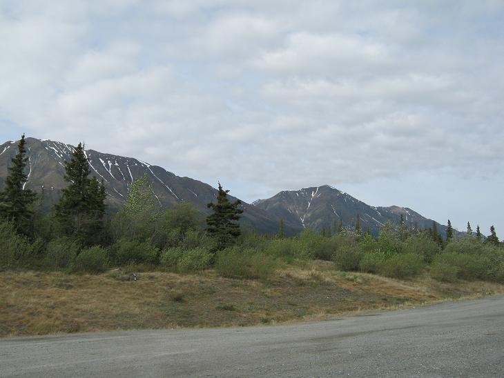


More Scenery
But in between all the bouncing, there was still some nice scenery:


Is this a swan or a snow goose?

Welcome to Alaska, Part 2
The road improved almost instantly when we crossed the border. We hope that was a good sign.

Ahhh.... New, smooth pavement. The first 14 miles had been freshly paved. We did run into some rough road later on, but nothing like what we saw earlier.

Skinny Trees
It seems the farther north we get, the skinnier the trees get. I'm not sure if this is because they get limited nourishment from the layer above the permafrost, or if it is an adaption to areas with heavy snow. Or both.


Need To Identify These Yellow Flowers
They seem to be some kind of yellow daisy, but I haven't found anything yet to confirm.


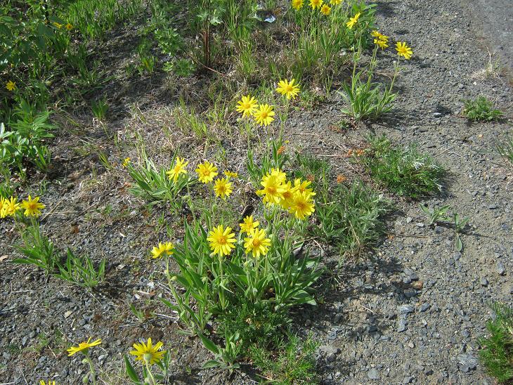
Alaska's Most Abundant Wildlife

Ok, I couldn't resist. I cropped these critters from one of my windshield scenery shots. Those specks are mosquitoes splattered on the windshield. Alaska is well known for its crop of healthy mosquitoes. Believe it or not, this windshield was shiny clean and freshly coated with rain-x at the start of the day.


Monday, May 30, 2011

Alaska Trip 2011: The Road to Whitehorse

This is page 14 of our Alaska 2011 trip journal. Click here for the first page. If you want to bookmark this journal, http://jeanne-travels.blogspot.com always links to the newest page.
Trip Overview
Now that I have figured out how to add Google Maps to the blog pages, I thought it might be nice to post an overview of part of the trip, to help put things in perspective. This is the long stretch of highway between Shelby, Montana, and Whitehorse, Yukon.

If you are looking at this in email, you might not see the map. In that case, just click on "View Larger Map", and it will bring up the map in your browser.


View Larger Map

A. Shelby, MT Last stop before entering Canada
B. Calgary, BC First stop in British Columbia
C. Edmonton, BC Capital of British Columbia
D. Dawson Creek, BC Start of the Alaska Highway
E. Watson Lake, YT First stop in Yukon Territory
F. Whitehorse, YT Klondike Highway crosses Alaska Highway

Whitehorse is a junction point of sorts. There are multiple paths you can take north across Canada to get to Alaska, but they all eventually end up in Whitehorse. Then from Whitehorse there are multiple routes to go on into Alaska. So this is not the last time we will see Whitehorse.

Please let me know if the maps are working for you, and if they are helpful.

Friday, May 27, 2011

Alaska Trip 2011: May 21-22 - How Will We Know if the World Ends?

This is page 10 of our Alaska 2011 trip journal. Click here for the first page. If you want to bookmark this journal, http://jeanne-travels.blogspot.com always links to the newest page.

Today we ventured back into the Yukon Territory wilderness. So if the world ended today as predicted, how would we know? No cell serice, no internet, no radio... Maybe the whole thing will pass us by if they don't know we are here? Our next major destination is Whitehorse, the Yukon capital. Looks like it will take us two days to get there.

Watson Lake to Teslin

There was an old log cabin along the road at this pullout. No indication around as to what it was for or how long it had been there.


From the same pullout, here is a view of the road ahead. This is near the Swift River.

Seems like we have always been able to find a nice, scenic spot to stop for lunch. Maybe it's because there just aren't that many ugly places. A couple of these are windshield shots, from before we pulled over for lunch.


Here is a view looking down into the valley from our pullout. This marshy area looked like it would be a good place to spot moose, but we still didn't see any.

Several places along the road here, there are rocky embankments like the one in these pictures. People have taken the larger rocks and spelled out messages or names. It's hard to see in these pictures without looking at the larger view, but it was plain as day when I took the pictures.

Rancheria Falls
This area had a nice nature trail to the falls. Ok, I admit I did not walk all the way to the falls, but I did get some nice pictures of the boreal forest along the trail. A boreal forest is the northern forest south of the arctic tree line. The trees are mostly pine and spruce, with aspens in some areas. The ground is frequently covered with moss, rather than other ground cover.


Gnarly old tree trunk!


I could be wrong, but I think this is moose scat. I put my foot in the picture (but hopefully not the scat!) to show the relative size - it's much larger than deer scat. But I'm not a wildlife expert, so please feel free to set me straight if I am wrong.

This is as close as we have come to seeing the elusive moose (elusive to us anyway) but we are hot on the trail.

Still No Moose
Another beautiful overlook, with lake and marsh below, but still no moose. There were actually two lakes you could see from this overlook. One of them was frozen, the other was not.


Still no Cell Service
We arrived in Teslin YT, where once again the phone showed service, but still calls would not go through. Maybe the world really did end, and we just don't know about it yet? (Just joking of course.)

We had a beaautiful view of the lake, and might have rested a day or two here if we had cell service and good internet. But we have been several days where no one could reach us if they needed to. We did manage to get a connection by going up to the restaurant, but that was about it. I'm still way behind on the journal, but I am NOT going to upload pictures at Canadian rates ($2 per megabyte).

Don't get me wrong, I am not complaining - just telling the story of our trip. We fully expected to go through areas where there would be no service, but this one caught us off guard. Nothing in our research indicated we would be quite so long without service. What made it frustrating was that there were a couple phone calls we needed to make. I really did expect to make connection in the towns along the way. Live and learn.
May 22, Looks Like the World Did Not End After All
Or if it did, we missed it.

Teslin advertises itself as the Gateway to the Southern Lakes. I guess all things are relative. It's hard to get your mind around something north of the 60th parallel being referred to as "southern" but it is, after all, southern Yukon. There are a number of lakes around here, and it appears water-related recreation abounds in the summer.

Gloomy, Rainy Day
Considering we have been on the road for three weeks, and it is spring, we really haven't had an extraordinary amount of rain, and most of it has been light. So I can't complain when we have a rainy day here and there. It is to be expected. These windshield shots show rain spots and occasional wiper blades. It's all part of the story.


It's just as well it was rainy today - It seems this stretch of road does not have very many pullouts. We did find one in time for lunch, and the rain had slowed down a bit, so we got some pictures without the wipers in the way. Clouds are still obscuring the mountains though.


Marsh Lake
Just in case you were missing those rainy windshield shots, here are a couple more. This is one of the southern lakes, Marsh Lake. It was just thawing, so it was part water, and part broken ice. The ice seemed to have an aqua or green color to it, and I was wondering if it was an illusion due to the ice. These pictures did not pick up the color very well. Too gray out, I guess.


Back to Civilization
We arrived in Whitehorse on Sunday afternoon, and were relieved to find that we finally had cell service. We will stay here two or three days, depending on what there is to see and so. So far, we have traveled 3500 miles, not counting separate sightseeing trips in the trailblazer.