Showing posts with label National Historic Sites. Show all posts

Monday, May 16, 2011

Alaska Trip 2011: May 7-8 - Indians and Explorers in North Dakota

This is page 3 of our Alaska 2011 blog. The first page is here. When we did the Glacier trip a couple years ago, there were a few places in western North Dakota that we had to skip because there was not time. We decided to take a couple days on this trip to see them.
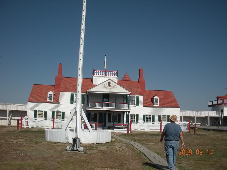
Fort Mandan State Historic Site
Fort Mandan is a reconstruction of the fort that Lewis and Clark built to spend the first winter on their expedition. The Mandan and other Indians in the area were mostly friendly, so the fort was as much for protection from the winter weather as it was for defense. It was triangular in shape - three walls - with the cabins and storerooms built in along each wall. They said the reconstruction was not at the original site, which they believed to be now under water.

The first picture is looking in the entrance of the fort, where you can see the flagpole in the center, and entrances to some of the rooms along the wall. The other shot is from further back, showing the entire fort.
Knife River Indian Villages National Historic Site
Apparently I forgot to take pictures here...
This National Historic Site is at the location of an old Mandan Indian village. It has a reconstruction of one of the sod homes, and an interpretive trail that describes some of the other structures that were in the village. There were also exhibits at the visitor center, and we saw a short movie about Mandan Indian life. Like other National Historic Sites, this one was interesting and informative.
Lake Sakakawea
Up here, they have a different spelling and pronunciation of the name of Lewis & Clark's Indian guide. We know her as Sacagawea, which I think is the more common interpretation. Or at least it's the one they used on the Sacagawea dollar coin.

Garrison Dam is on the Missouri River, creating Lake Sakakawea, which stretches across a good portion of the western half of North Dakota. The earthen dam reminds me of Lake Shelbyville near home, but on a much larger scale. I suppose that makes sense, as they were both Corps of Engineers projects.


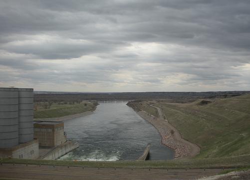
The first picture is from the top of the dam. The large cylindrical structures are filled with air, and serve as a shock absorber of sorts for the water coming through. The next picture is also from the top of the dam, looking out across the lake. Most of the winter ice has now melted, but you can still see some where the waves lapped up on the far shore. Some of these pictures also give a pretty good look at how gloomy and rainy it was the day we were here.
Unlike Lake Shelbyville, Lake Sakakwea has a spillway that is used to prevent water from breaching the top of the dam. And the rip-rap is pinkish instead of white. This picture of the spillway shows some of the leftover ice accumulating near the spillway gates. There was no water running on the other side, so I presume it was blown there by the wind.
Here are a couple more shots across the lake from near the spillway. We didn't stay here very long, because the wind blowing across the lake was pretty cold. These shots also give a pretty good look at the clouds. We had light rain off and on all day, but thankfully no heavy rain.


Double Ditch

Double Ditch was another old Indian settlement. I don't remember if it was Mandan, Hidatsu, or Arikara. All three were similar, and in the same general area. Archaeologists called this area Double Ditch because of two concentric ditches around the perimeter of the village. The ditches were used for defensive purposes, sort of like a moat or battlement. They had upright poles to make it difficult to cross. The outer of the two ditches was the older, and was apparently when the village was at its population peak. The newer ditch was built later, as the population shrank.

While at double ditch, I took another picture looking out across the prairie. This is pretty typical prairie scenery - a whole lotta nuttin.
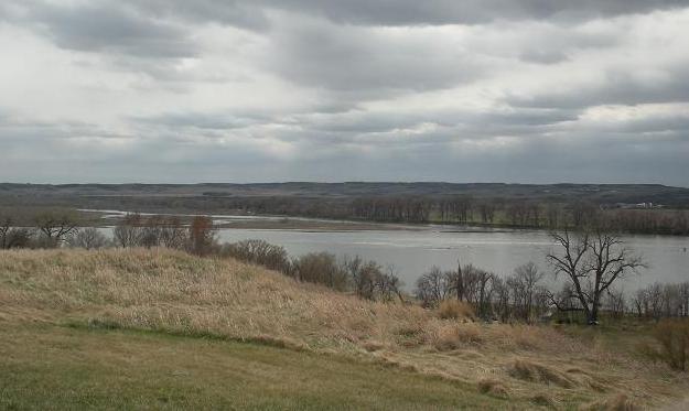
Missouri River
Here are a couple nice shots of the Missouri River below the Dam:


Sunday May 8: Travel Day
On Sunday, we moved from our spot near Bismarck, to Dickinson, ND, for one more day of sightseeing before we move on to Montana. This part of North Dakota is apparently experiencing some kind of an Oil Boom. You see lots of wells and drilling rigs, trucks carrying drilling equipment and supplies, and camp sites with row after row of identical small travel trailers, apparently for the workers to stay. I'm guessing there is no unemployment problem here. I'm not sure why it takes so many workers and so many trucks - I guess I need to learn more about driling for oil.

Thursday, September 17, 2009

Vacation 2009 - Heading to North Dakota

This is page ten of our vacation 2009 blog. The first page is here.
Big Sky Country
If you live in the Midwest, there is one unalterable fact about traveling to the West. It doesn't matter how far North or South you go, you still must cross the Great Plains before you get to the mountains, and you must cross again on your way back.

We drove over 500 miles in Montana after leaving the mountains and Glacier National Park.
As we drive across northern Montana, I can see why they call it "Big Sky Country". Sometimes, the sky is about all you can see. I sit back and imagine that the wheat fields are native grasses, and the grazing cattle are some of the great herds of buffalo that once roamed the area. The occasional towns might be Indian villages. Though the area has changed dramatically in the last hundred years or so, in some ways it has not changed at all.
Believe it or not, I did not take any pictures at all during the trek across the Montana plains
Some day I may retrace the steps of Lewis and Clark across this vast land, or follow the Oregon Trail or the Pony Express. I am sure there are many interesting places in the Great Plains, islands in this great sea, such as we found at North Platte. But for now, these destinations are not as high on my list of places I want to see. When crossing the plains takes a couple days out of a limited itinerary, it seems more of a barrier than a destination.

Fort Union Trading Post
The restored Fort Union Trading Post is on the Missouri River, and is quite literally on the border between Montana and North Dakota. The parking lot is in Montana, and the fort itself is in North Dakota. If you take the right road the first time, it is only about 20 miles off the highway, and is definitely worth a stop if you are traveling on U.S. 2 in the area. We drove a little farther than that, because we were debating whether we had enough time for this stop, and ended up cutting across and coming up from the south.


Fort Union was not actually a military fort, but it was fortified like one to protect the goods and inhabitants. Just inside the front gate, we found the Trading Room, where we chatted with a man in period costume about the fort and how the trading was done.

The first thing you see inside the walls is the bourgeois house, a grand two-story structure that almost seemed out of place amid the more meager surroundings. The fort's manager was known as the Bourgeois, reflecting the French Canadian part of the American Fur Company's background. The Bourgeois and his chief clerk and families lived in the Bourgeois house. Other employees lived in the dwellings and shops outside the house. Some of the employees who took Indian wives lived in teepees outside the fort.


The difference between the Bourgeois house and the outer dwellings was startling. Although there were no restored dwellings on the site, you could see from the foundations that a dwelling was smaller than a typical room in the house.

The restored Bourgeois House, thankfully, was air-conditioned. It was a fairly hot day on the prairie when we were there, and I just don't deal with heat the way I used to. The house now serves as the visitor center, and houses a small museum with artifacts and more information about the trading post and the surrounding area.


North Dakota Badlands

Heading South from Fort Union, we catch our first glimpse of the North Dakota badlands just before getting to the North Unit of Theodore Roosevelt National Park.