Fort Nelson Heritage Museum
Before we hit the road, we walked over to the Fort Nelson Heritage Museum, which was basically next door to the campground. Turns out it was closed, but they had a lot of stuff sitting outside, so we took a look anyway. First, a couple views of the museum itself.
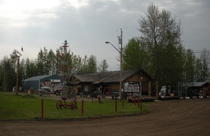

The official historical mile 300 marker is right in front of the museum

Stone Sheep are a relative of the bighorns, but the horns are thinner, and they are brown rather than white. They are only found in northern British Columbia, and southern Yukon. Stone sheep and their white cousins, Dall Sheep, are referred to as "thinhorns" to distinguish them from the Bighorn sheep that live farther south. This bronze statue commemorates the largest recorded specimen of Stone Sheep.

Here are some old airplane engines or parts of engines, probably World War II vintage.


Below is an old oil drilling rig, and a guardrail shaped like a crayola crayon. I dom't imagine the crayon guardrail was either old or historic, but it was cute.


After leaving the museum, we went back to the campground, got everything hooked up and ready to roll, and drove back into town for fuel. When we came back by the museum, we saw the closed sign was gone, and they were now open. Oh well, too late. "We missed it by THAT much!"
Check Your Fuel
Here was our first clue that we were about to drive into some pretty lonesome countryside.

Heading Across The Rockies
They say the next 200 miles is one of the worst stretches on the Alaska Highway. We have been pretty much following alongside the Rocky Mountains, but starting at Fort Nelson, we head up and across. They warn of steep grades, narrow shoulders, and rough patches of pavement from frost heaves. Here, we see a little bit of a preview of the mountains ahead. So far, we have not seen much bad roadway, but we will take things slowly, which should help avoid the unexpected.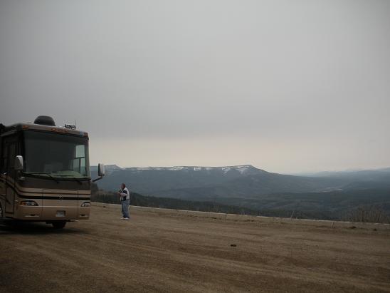


From where the above pictures were taken, here is a look up the road ahead...
...and a couple of views from another of the many overlooks along the road.


We spotted a black bear in the ditch along the highway, but there was not enough time to try to get a picture. A few miles down, we spotted this critter. For this shot, the windshield was not only dirty, it was rain-speckled. I know these pictures through the windshield are really poor quality, but when you see wildlife along the road, you don't have time to set up a really good shot. It may not be pretty, but it captures the memory.
Lunch along a mountain stream

We found this pretty mountain stream, a nice place to stop for lunch.


More Wildlife

When we spotted these critters, we weren't sure if they were elk or caribou, especially since neither have antlers this time of year. We did a little research, and based on the coloration, we are pretty sure these are caribou.
I make no apologies for the quality of these thru-the-windshield shots.
Along this stretch of road, we also spotted a beaver dam but no beaver, and a porcupine. Had no chance to grab a picture of either.


My Favorite Overlook of the Day
This spot was just amazing. It seemed like every place you looked, there was another beautiful view. I'll let the pictures speak for themselves:


Summit Lake
Summit Lake is near the highest point on the Alaska Highway, at about 4300 feet. I did not see anything marking the exact spot.

These two pictures were taken through the windshield. There were no pullovers at this point, and the view was so stunning I did not want to lose it. I like the visual effect here - between the gray day, and the snowy mountains, and the icy lake, it comes out looking almost like a black-and-white photo, but the yellow stripe on the highway reminds you that it is not. These were taken in the middle of the afternoon, so they were not twilight shots or anything like that.
The two pictures below were taken when we finally did get to a pullout. The view was just not the same, so I'm glad I did the windshield shots.
The two pictures below were taken when we finally did get to a pullout. The view was just not the same, so I'm glad I did the windshield shots.


Toad River
After Summit Lake, we drove on to Toad River, where we camped for the night. We have not had cell service all day, which was not surprising since this area is pretty unpopulated. But given its remote location, we were a bit surprised to find that the campground had internet.We have now gone a total of 3,015 miles since the start. Tomorrow we continue our trek up the Alaska Highway.


This comment has been removed by the author.
ReplyDeleteAwsome picts Jeannie from Dave and Laura... Have a safe Journey.
ReplyDelete