We slept in a little this morning, then headed out for some more points of interest in Whitehorse.
Beringia Center
This museum is dedicated to some of the natural history of the Yukon, some of which applies to Alaska as well. A good portion of Yukon and Alaska was untouched by glaciers in the ice age. The coastal mountains trapped all the snow, so there was simply not enough moisture to create glaciers. This makes the area highly attractive to archaeologists, since the land was not scoured clean by the movement of the glaciers. To highlight this, they have models of the wooly mammoth outside the building, and a skeleton on the inside. When they talk about a land bridge from Siberia to Alaska, I always imagined a narrow strip of land at the point where you can see Russia from Alaska. There was actually a huge strip of land between the two continents. This map shows the relative position of the land, which they called Beringia. It's a lot easier to imagine people crossing that stretch of land than it is to think about them finding a narrow bridge. As the ice age ended and the massive glaciers began melting, the seas rose accordingly, and this stretch of land was inundated.
Apparently they have found skeletal remains of beavers as large as bears, so native tales about the giant beaver were not just myth.
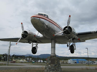
The World's Largest Weathervane
OK, it's not the largest ball of twine, but it was interesting. They have mounted this DC-3 on a pedestal that allows it to rotate in the wind. There was only a slight breeze while we were there, but it was enough to move it around. They say it only takes 3-4 mph breeze to make it move. A rooster on a barn probably takes that much before it moves.Yukon Transportation Museum
Dedicated to various means of transportation in Yukon, it had displays related to the building of the Alaska Highway, plus a few vintage vehicles, boats and airplanes.Miles Canyon
 After supper, we took an evening drive through Miles Canyon, just south of Whitehorse. This scenic, narrow canyon has almost vertical walls. The rock here is basalt from a now-extinct volcano. When the lava cools, it contracts, and fractures vertically. You can see these vertical lines on the canyon walls. When the river cuts through the area, the rocks split along these fractures, leaving the vertical walls.
 There is a footbridge that crosses the canyon here - I walked out onto the bridge to get good views up and down the river.
Above Miles Canyon
 Further up the road, there was an overlook that looked down at the canyon where we just were. It also had some nice views looking the other direction.
On the way back to town, we drove by the lake and saw this float plane on the water, getting ready to take off...

...And saw a few more parked on the bank. We did not catch the plane taking off, because when it got to the position it wanted for takeoff, we were not in a position to catch it.


No comments:
Post a Comment
Anyone can comment, but I will look at all comments before allowing them to be published, so don't expect them to show up immediately. This is to weed out the inevitable spam posts. If you do not wish to register, you might include a clue in your comment so I can figure out who you are.